Seek and Illustrate the Truth -
Call Now 1-866-805-0610

What is Laser-Based Photogrammetry?


For starters, it’s a mouthful!
Let’s start with answering, “what is photogrammetry?” The Merriam-Webster Dictionary defines this as “the science of making reliable measurements by the use of photographs and especially aerial photographs.” A fundamental principle of photogrammetry is that if one measurement of a subject seen in a photo is known, other measurements can be determined through mathematical calculation.
Traditional photogrammetry is a staple of the construction, architecture, urban planning, mining, agriculture and surveying industries. By taking high-altitude or wide-angle photos of a large area of land, it becomes easier to understand and quantify an area based on known land measurements. This quantification can help planners effectively coordinate a project’s execution.
Like the industries mentioned above, photo and video media are becoming invaluable elements for litigators and forensic specialists. However, extracting reliable measurements from visual evidence such as security camera footage, body-worn camera footage or cell phone media can be much more complicated than overhead plots of land. For this reason, 3D Forensic pioneered the forensic process of “Laser-Based Photogrammetry,” a digital reconstruction process that infuses several technologies to determine precise measurements from photo and video.
So what is Laser-Based Photogrammetry?
Laser-based photogrammetry is a process for determining unknown measurements in photo or video based on known measurements through laser scanning. As stated in past articles, 3D laser scanning technology is the most effective and efficient way to preserve pertinent measurements of case evidence. It also enables experts to digitally analyze case elements at any stage of a case and serves as a foundational blueprint for several types of advanced forensic analysis.
Because forensic laser scanning can capture physical measurements to a millimeter’s scale of accuracy, scans of forensic evidence can be used to certify measurements of elements seen in photo or video footage of an incident. This process is especially effective for creating accurate, to-scale 3D models of environments, vehicles and people, and is a crucial facet of the 3D Working Model.
Use Case
Let’s use a scenario where critical measurements could only be attained from a photo taken the day of the incident. A recent case involved a skier traveling down a slope that was recently blanketed from an avalanche. Near the end of the slope, signs directing skiers towards the safe exit were covered, and the case’s plaintiff ended up taking a trail that led to a steep drop-off.
After soaring past a few trees on their last run, the drop-off of at least ten feet made the plaintiff fall from smooth snow to the icy concrete below. Recovery from this impact took the plaintiff through a coma, multiple surgeries and extensive rehabilitation.
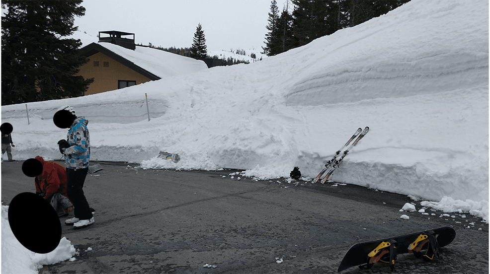
During the ensuing case, debate about the size and effect of the drop-off led to disagreement among the plaintiff and defense attorneys. No official measurement was taken of the road trench’s height on that day, and the injury had occurred years ago by this point in the case, so the snow buildup certainly wouldn’t have been the same. However, multiple witness photos showed the drop-off in the background while emergency responders were helping the plaintiff. These photos captured two angles of the edge the plaintiff had fallen from; now, how could we determine the heights?
Process
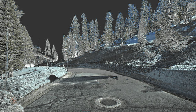
1 Forensic Laser-Scanning: Through laser-based photogrammetry, our team can ascertain certain measurements seen in these photos and determine the height of the drop-off. First, our team went to the incident location to capture forensic laser scan measurements of the environment. One primary element that can be seen in the photos that remained intact was the roadway onto which the plaintiff fell. In total, the team captured necessary laser scans in less than one hour at the scene.
Next, the team brought these scans back to the office where the data could be uploaded into 3D modelling software. Here, visual software enabled our experts to observe the area from all angles and take measurements accurate to a millimeter’s-scale of any section relevant to our analysis.
2 Camera Matching: The next step required overlaying the original photos from the day of the incident over a view of the scan data from the very same perspective of the photos. To do this, our team treated the original photos for dimensional distortion. This distortion is present in most cameras and typically allows cameras to zoom in or focus on specific areas, but also misaligns the dimensions and aspects of what is captured.
After treating the image distortion, we could properly overlay the original photos onto the view of the 3D model from the same perspective as the cameras. It’s important to three-dimensionally match the 3D modelling software’s perspective to the perspective at which the original photo was taken to ensure that all elements are as aligned as possible, including the scan data of the roadway both on the day of the incident and from scan data.
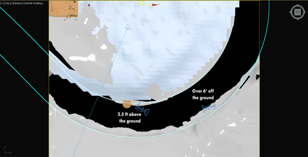
*Camera-match made for demonstrative purposes
3 3D Reconstruction: With the difference in before-and-after views clear as possible, we can now set the digital stage for measurement extraction. Our team began creating visual 3D models of the environment from the day of the incident on top of the laser scan data. This includes modelling the portion of the road that was visible, the focused snow wall, and surrounding area that included trees and other snow mounds. When representative models are developed and aligned from one photo’s perspective, their alignment can then be verified from another photo’s perspective to ensure three-dimensional consistency and accuracy.
4 Measurement: After 3D modelling all pertinent elements seen on both photos and ensuring their locations in the software match where they are seen in the photos, we now have an accurate and measurable 3D-reconstructed environment from the day of the incident. Now, our team only needs to use the 3D software to measure the base of the roadway (from laser scan data) to the top of the 3D modelled snow wall to verify that the plaintiff dropped of a fall of 27 feet.
After submitting demonstrative exhibits, a forensic animation and an explanatory deposition, our team connected how the fall from this height led to such serious injuries for the plaintiff. This measurement also punctuated the dangerous condition caused by the ski slope’s failure to direct skiers to safety, leading to a significant settlement from the slope operator for the injured skier.
Talk to Our Forensic Team
Let Us Help You Seek & Illustrate The Truth
By submitting this form, I confirm that I have read and understood the 3D Forensic Privacy Statement.
"We have used Jason Fries and his team twice to create medical videos depicting complex surgeries. The videos impressed both the jury and the defense attorneys. Perhaps most helpful, Jason will work on short notice and provide a persuasive product."
Robert Igleheart
Rouda, Feder, Tietjen & McGuinn